They’re Back: Northeast Corridor Commission Sets Out Plan To Implement NEC Future
In 2016, the Federal Railway Administration released a plan to bisect Charlestown with a new high-speed track that would have run from Charlestown’s western edge to its eastern edge—through homes in Burdickville village, across a four-generation farm-to-table operation on top of Schumankanuc Hill, over Native American tribal land, through the center of the 1,112-acre Carter Preserve (owned by The Nature Conservancy), through the middle of the Revolutionary-era Amos Green Farm, through adjacent properties protected by conservation easements, through federally funded Historic Columbia Heights housing, and then over Historic Kenyon— to reconnect with the existing railroad near the eastern edge of town in the Great Swamp.
Charlestown was inside the “Old Saybrook to Kenyon Bypass” which was part of the “preferred alternative” in the Tier 1 Final Environmental Impact Statement (EIS). Greg Stroud and his organization SECoast, the Charlestown Citizens Alliance, Charlestown’s Town Council and many others worked tirelessly against the Bypass. When the Federal Railroad Administration released their Record of Decision on July 12, 2017 and dropped the “Old Saybrook to Kenyon Bypass” from the plan, it was great news and a big win for Charlestown; however the EIS required a study that left the door open to the Bypass.
Visit Our Railroad Page To Learn More About Past Work To Stop The BypassThe Northeast Corridor Commission is made up of 18 members, including representatives from each of the eight Northeast Corridor states, the District of Columbia, Amtrak, and the US Department of Transportation. The Commission has now released Connect NEC 2035, a 15-year development plan and planning process for the Northeast Rail Corridor. Charlestown and the old Bypass are not in any development plans, but we are still an important part of the planning process.
You Can Read The Entire 274 Page Overview Of Connect NEC 2035Neither the name of Kenyon nor that of Charlestown are found in the pdf linked above, and the “maps” have the two curves that exist in the Charlestown tracks now, so in the short term there is not a realignment proposed.
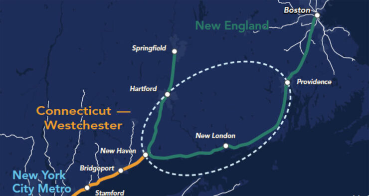
But what the maps do have is a giant circle covering our region. The “New Haven to Providence Capacity Planning Study” is on the table and that is extremely important and potentially dangerous for our town. The banner image in this post shows the study area.
We’ll keep you updated as we learn more, and we may also need your help in contacting our federal and state officials as we move through the planing process. It’s our plan to keep working to protect Charlestown and the natural resources and public and private property that would be destroyed if anything like the “Old Saybrook to Kenyon Bypass” returns.
The Connecticut Examiner has more of the story at https://ctexaminer.com/2021/07/14/a-new-hartford-station-resolving-high-speed-rail-bypasses-headline-nec-future-announcement/ (Greg Stroud, is now the Editor in chief at the Connecticut Examiner)
There is a second plan for high speed rail, called North Atlantic Rail. This plan is directed by well-known planner Robert Yaro. The second plan proposes a new route that would track to Long Island, cross Long Island Sound with a 16-mile tunnel to New Haven, and then proceed north to Hartford. From Hartford it would travel east to the University of Connecticut at Tolland, Connecticut, and then on to Providence and Boston. This proposal avoids Charlestown and the coastal route, but it’s not clear if this is an alternative or an additional route. It also punches a hole in the forests of western Rhode Island. Mr. Yaro was on Governor Mckee’s Facebook live feed talking about the plan earlier this month. Mr. Yaro starts about 20 miniutes into the video at https://www.facebook.com/GovDanMckee/videos/247952223467543/.

You can learn more about the author, Ruth Platner, at her profile page.

July 19, 2021 @ 6:30 pm
Thanks for the info! I was afraid of this. New rail lines should be built around and over top of existing ones, just like they do with highways, exits, monorails and trams etc. I have already written to the WH and contacted our senators’s offices about this and that is very easy to do for anyone else who would like to do the same.
July 19, 2021 @ 12:34 pm
Thank you for keeping us informed of this plan. We need to stay vigilant to protect the resources we so treasure.
July 16, 2021 @ 8:12 am
Thanks Ruth, for the heads up. It takes community vigilance , engagement and support to keep the town aware and ready to combat proposals that impact the town.
July 16, 2021 @ 8:10 am
I agree … as usual many thanks to Ruth and the CCA for keeping us so well informed.
July 15, 2021 @ 2:40 pm
Another great article by Ruth Platner.
It seems Amtrack didn’t learn anything the first time about how feisty citizens fron Southeastern CT and Southwestern RI are. I hope this present town council will be as strong as the 2016 council. They set the bar extremely high.