
Charlestown’s Conservation Corridors Connect The Ocean To Northern Forests
The following is shared with us by the author Ruth Platner. Ruth Platner is Chair of the Charlestown Planning Commission.
At the global and local level, plant and animal species are disappearing as their habitats are lost to development or altered by climate change. Focusing conservation efforts on areas that connect habitats helps nature adapt to climate change and other changes in the landscape.
Charlestown contains part of a corridor of open space that stretches from the barrier beaches of Charlestown to the border with Massachusetts in Burrillville and then beyond to the mountains of northern New England and Canada.
In his testimony on the Invenergy power plant’s negative environmental impacts, Scott Comings of the Rhode Island Nature Conservancy referenced regional maps of low light pollution and open space connectivity. In both of his figures, Charlestown makes up the southern terminus of this important wildlife and conservation corridor and Burrillville occupies the northern end. I have annotated those maps with Charlestown’s position and included them below.
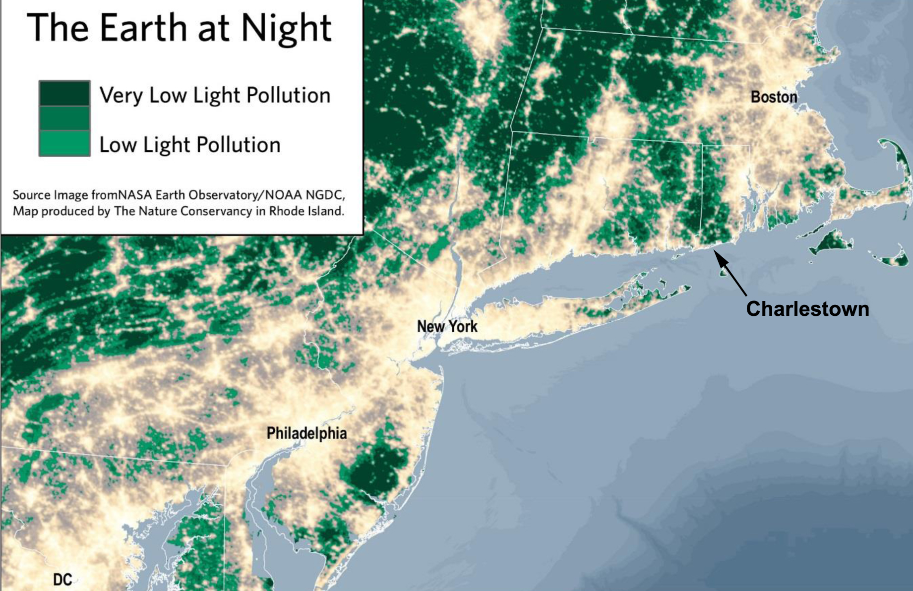
The “Earth at Night” graphic above shows areas of low light pollution in green. Locate Charlestown on this map and then follow the green column to Burrillville at the Massachusetts border. These are the darkest, least developed areas of Rhode Island. And in the regional context, it is part of the only undeveloped area along the Eastern Seaboard that connects the Atlantic Ocean to the inland forests of New England and Canada. Looking at this map you can see how important Ninigret National Wildlife Refuge is to birds migrating along the Atlantic Flyway. The arrow in the map above points right to Ninigret. After days flying near some of the biggest, most brightly lit metropolitan areas in the world, Ninigret offers migrating birds the first true darkness and a gateway to miles of relatively unfragmented open space on their journey north.
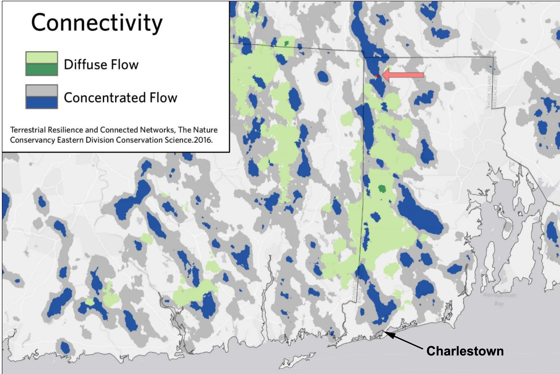
The second figure, labeled “Connectivity” above from Scott Comings shows patterns of ecological flow. “The areas of diffuse and concentrated flow are ecologically valuable and are good targets for conservation. Blue concentration zones can be particularly valuable as conservation priorities due to their irreplaceable nature.” The white areas of the map (areas that are not blue, dark gray, or green) show barriers to wildlife movement. ( You can read Scott Comings’ entire testimony at the EFSB website.)
Charlestown provides the coastal gateway to this important wildlife corridor. The blue areas on the map are where species movement is concentrated in a narrow area. These are unique pathways where alternative pathways are not available. If these unique pathways are lost, the conservation areas become islands, no longer connected to the forests of Northern New England. Charlestown is dominated by these irreplaceable wildlife corridors depicted in blue and grey on the map above.
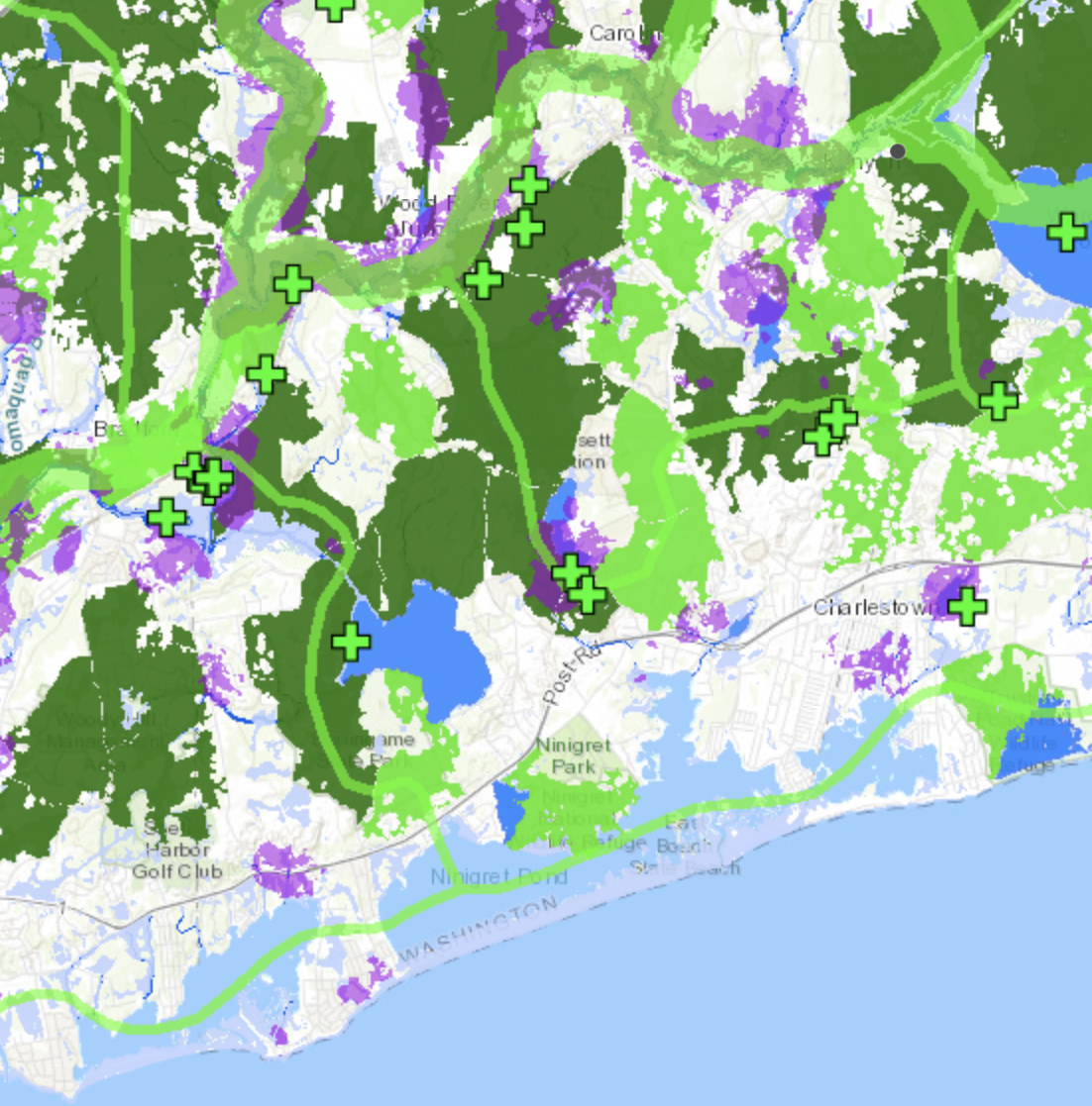
The Rhode Island Department of Environmental Management (DEM) has mapped important wildlife corridors in Rhode Island. The map below includes Charlestown.
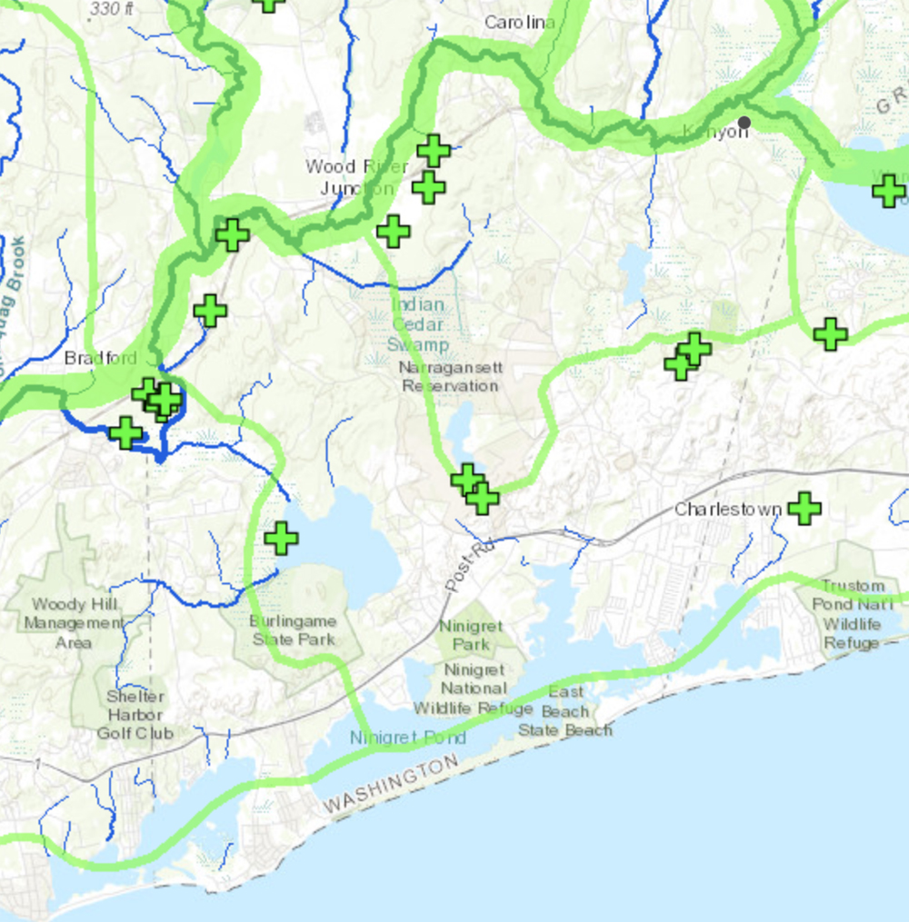
In the map above, the Wild and Scenic Pawcatuck River (dark green) forms the northern boundary of Charlestown and is also one of the main wildlife corridors. These wildlife corridors are depicted in light green. The coastal ponds are a wildlife corridor, connected to the Pawcatuck River through the protected land in Burlingame. Other wildlife corridors connect north to the river or east to South Kingstown. The green crosses “+” depict the location of areas of critical or uncommon habitat.
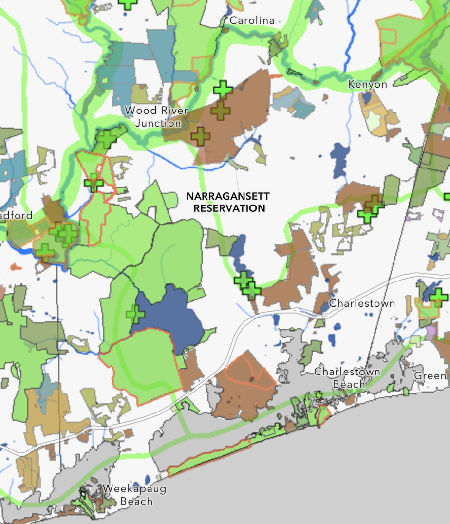
The next map depicts Ecological Land Units in purple.
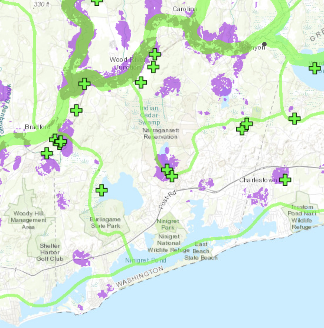
Ecological Land Units (ELU) are land types that typically support large numbers of plant and animal species. A specific ELU has a unique combination of soils, geology, landform, and elevation. An area with many different types of ELUs will have many different types of plant communities, thus high biodiversity. These are the areas mapped in purple on the above map.
The DEM map below depicts un-fragmented forest overlaid on the map of wildlife corridors.
The map above depicts unfragmented forest blocks of greater than 500 acres in dark green and areas greater than 250 acres but smaller than 500 acres in light green. The wildlife corridors follow these forested areas. Much of the protected open space in Charlestown is forested and other private land that is not developed and is still forested supports the conservation value of these corridors.
The DEM map below shows different types of protected open space overlaid on the map of wildlife corridors.
DEM has mapped these in different colors by ownership. These are public town, state, federal, Nature Conservancy, Charlestown Land Trust, and private conservation easements. The wildlife corridors tend to follow the protected land both because these wildlife corridors have been high priorities for land conservation and because where land is already developed the opportunities for conservation may have already been eliminated.
Charlestown contains critical wildlife habitats and recreation areas that are important in their own right, but in a regional context they are even more important. Fragmentation of this corridor diminishes the importance of the entire corridor for both wildlife and recreation.
Charlestown is connected to northern forests by a corridor of Rhode Island’s most rural areas, with large tracts of contiguous forest, rivers, wetlands, and important wildlife and outdoor recreation areas. Charlestown’s natural resources are important, but that importance is greatly magnified by connecting our coastal conservation areas to northern forests.
Not all of the wildlife corridors, critical habitats, and Ecological Land Units in Charlestown are in protected open space. These gaps in protection are important areas to target for preservation to maintain the ecological integrity of the corridor of open space that stretches from the beaches of Charlestown to the border with Massachusetts.
You can learn more about the author, Ruth Platner, at her profile page.
The banner image is a photograph of the Pawcatuck River flowing through the Carter Preserve in Charlestown by Cliff Vanover.
January 13, 2021 @ 8:18 am
Thank you, Ruth. This was an excellent, thorough article.
January 7, 2021 @ 4:24 pm
Thanks from me too Ruth for an informative presentation of this data. For me the first map is especially compelling showing the “dark skies” corridor of western RI with eastern Ct squeezed between the conurbations of Boston, New York City, Hartford etc. … and Charlestown’s key role in this. So I appreciate and thank you for your work and others to maintain and protect this, and not become developed like our neighbour communities of Westerly, South Kingstown, Narragansett etc.
January 6, 2021 @ 4:26 pm
Most people do not realize what “ecological units” mean in terms of the importance to all living creatures including us. We forget the myriad of insects, critters that decompose waste, bodies and leaf litter; leaf litter that harbors overwintering moth larvae, and seeds waiting to sprout, minute soil organisms that create healthy soil.These all translate into life as we know it for wildlife and us. Without all these workers our whole system could collapse and we cannot put back what is lost. As well as the unfragmented areas each backyard can play a role in providing for these creatures and add to the overall wealth of species we rely on. Every subdivision, every road, every parking lot destroys some of these. We can help put them back by planting useful native plants, keeping as much native material as possible, providing the right conditions for a variety of creatures and by supporting the acquisition and preservation of open space and especially unfragmented forest. Read Doug Tallamy’s book Bringing Nature Home or his new book Nature’s Best Hope. We are fortunate to have a keystone species, oaks that host a wide variety of insects that in turn feed birds that feed on caterpillars for example. We can start a new year with new resolutions to protect what nature is left and create more habitat bit by bit.
January 2, 2021 @ 8:49 pm
Great article! Thank you for all of your efforts to protect these critical and quickly deminishing wildlife habitats and our beautiful RI recreation areas.
January 2, 2021 @ 11:32 am
What a terrific combination of visuals, facts and context for the reader. Thank you, Ruth Platner ! It helps us see our old farm, also known as the Amos Green Farm, in yet another important way.
January 2, 2021 @ 8:04 am
Excellent article Ruth. Could you send me a digital copy to share with the Charlestown Land Trust membership? We can’t stop development but ‘thoughtful’ development is crucial moving forward.
Happy New Year!