Ruth Platner: We Stopped The Train In Its Tracks
A version of the following letter appeared in local newspapers and is shared with us here by the author Ruth Platner. Ruth is the current Chair of the Charlestown Planning Commission and is a candidate for Planning Commission in the 2020 election.
Through heroic effort, Charlestown’s government and our residents stopped the plan by the Federal Railroad Administration (FRA) to destroy northern Charlestown. Our political opposition did nothing then or now—except to offer divisive criticism.
In 2015, the FRA sent a form letter to the Narragansett Indian Tribe and 15 towns in Rhode Island. Most of these governments have no recollection of receiving any communication from the FRA. For those who do remember, it appeared to be no more than a promotional brochure. Federal law requires that the FRA send a notification, but the letter was deceptive by design and succeeded in not prompting responses.
It was actually a bit of luck that we didn’t find out in 2015. At that point the debate was a choice between two routes. One that skirted Providence by running Boston-New York trains through Worcester and Connecticut. The other included the destructive bypass through Charlestown. Our state government and Congressional delegation were fighting hard to keep Providence a high-speed rail stop. To save South County we would have had to fight for a route that excluded Providence. That was a fight that South County couldn’t win.
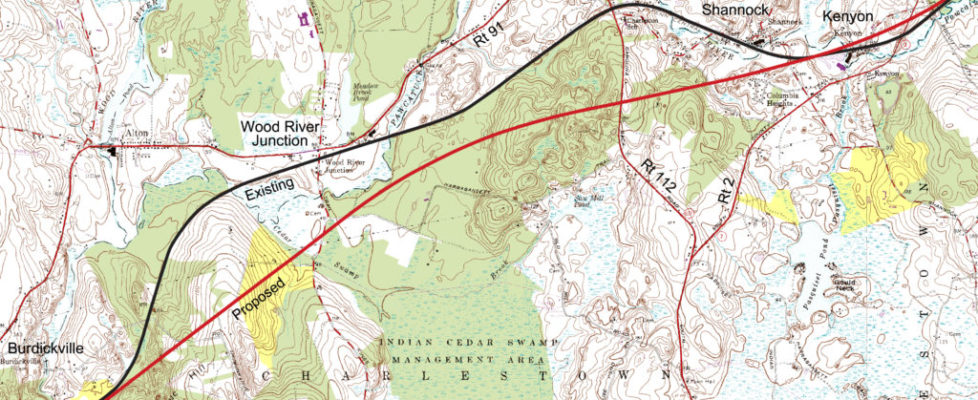
By chance I saw Jack Reed in a televised press release on December 16, 2016 say Providence had “dodged a bullet” and how pleased he was by the FRA’s proposed final plan named “NEC Future”. My web search discovered that plan, but Charlestown was not named in the 10 thousand pages of materials at the website. My husband Cliff Vanover, who is a cartographer, found an 8-inch wide map of the proposed route buried in an appendix without municipal or state boundaries and only a few major roads depicted that spanned from New London to North Kingstown. Charlestown makes up one inch of that map. He blew up that little piece of map, lined up Rts. 2, 112, and 91 on zoning maps and maps of natural and cultural resources and revealed a path of destruction through our town. The maps showed a new high-speed track that would run from Charlestown’s western edge through homes in Burdickville, across a four-generation farm-to-table operation on top of Schumankanuc Hill, over Native-American tribal land, through the center of the 1,112-acre Carter Preserve (owned by The Nature Conservancy), and splitting the Revolutionary-era Amos Green Farm, adjacent properties protected by conservation easements, and historic Columbia Heights, then over historic Kenyon to reconnect with the existing railroad near the eastern edge of town in the Great Swamp. Those maps were quickly released at the Charlestown Citizens Alliance website, where there were over 25,000 views in two days. It was the first time anyone, including many in state government, had seen the details and impacts of what was proposed.
Our Town Council went into immediate action alerting residents and lobbying state and federal officials. Through thousands of hours of combined effort they gained the support of over 100 international, national, state, and municipal organizations and thousands of residents statewide. Together we succeeded in removing the “Old Saybrook to Kenyon Bypass” from the plan and the coalition the Council formed with those other organizations has put us in a much stronger position going forward.
Charlestown Town Council candidates Sheila Andrew, Cody Clarkin, Susan Cooper, Bonnie Van Slyke, and David Wilkinson and Planning Commission candidates Gordon Foer, Walter Mahony, Frances Topping, and me, Ruth Platner, are committed to continue to protect Charlestown from threats to our town whether they come from a large corporation, an initiative of the state legislature, an action of a state or federal agency, or any other source. We ask for your consideration and vote.
You can learn more about Ruth at her profile page.
The banner image in this post is one of the many maps prepared by Cliff Vanover in December 2016. This map shows a composite of open space and farmland bisected by the new rails in red. For more about the NEC Future plan and its impact on Charlestown, visit our Railroad page.


October 2, 2020 @ 10:31 am
Agreed, and as always many thanks to all who work so hard and volunteer so much of their time for these efforts.
October 1, 2020 @ 8:43 pm
I will always be grateful that our town council and the many regular folks beat this horrific idea! We are so fortunate to live in this little piece of Heaven. When I moved here almost twenty years ago, a longtime resident told me,” This is God’s country.” He is so right…we can never take it for granted. Vote for the people that love this little town as much as I do.
Lisa Savino
September 30, 2020 @ 10:00 am
Mr. Rzewuski knows what he is talking about. As past Chairman of the Charlestown Zoning Board of Review, he keeps up with plans and programs that affect our land use and land cover. Thank you for your vote of confidence.
September 29, 2020 @ 7:26 pm
All CCA candidates have my vote. When FRA hit the fan our Town Council, Planning, Nature Conservancy, members of the Narragansett tribe and a large group of citizens banded together and came out united. Thank you.