Without Notice To Town, DEM Begins Development In Burlingame’s North Camp – Or Did They?
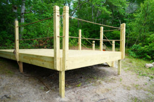
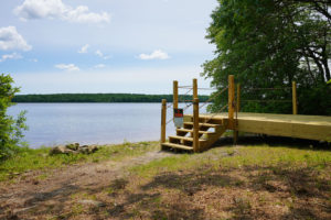
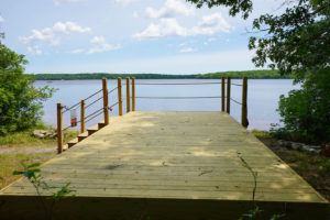
Update June 28 – According to staff at DEM, the camping platform on the north edge of Watchaug Pond was a “demonstration” campsite built by the concessionaire and was removed yesterday, June 27. It was constructed as part of the concessionaire’s proposal to State Parks and Recreation staff for revival of North Camp and was a temporary installation.
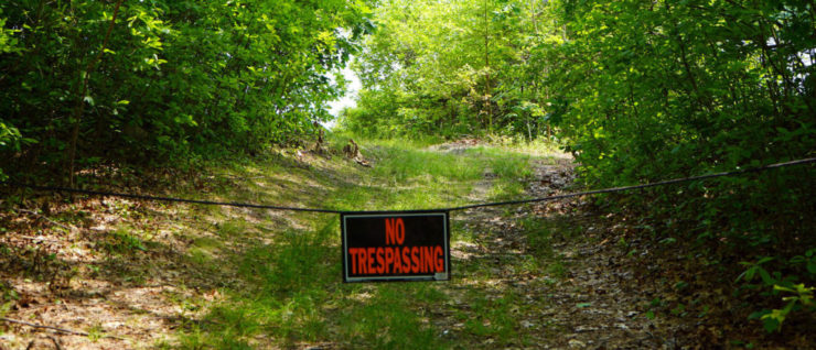
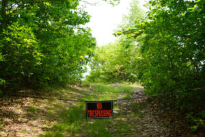
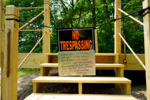
A hiker who walked to the pond at the old North Camp today tells us the platform is gone and the lumber was trucked out the morning of June 28. The no trespassing signs are down too.
What this means is that re-development of the camp has not yet begun, but DEM may of-course accept the proposal from the management company to open up 96 camp sites on the north side of Burlingame.
——————————————————————————-
Without any notice to the government or citizens of Charlestown, a concessionaire under contract to DEM has begun clearing and construction in the North Camp area of Burlingame State Park.
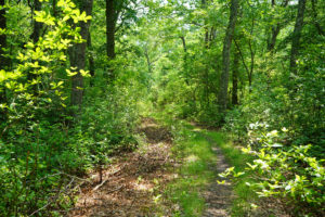
North Camp, which is sited on the north side of Watchaug Pond was once a primitive camping area in the state park, but that use has been abandoned for more than 25 years. In the intervening years the camp has returned to wildlife habitat and passive recreation use. A hiking trail passes by the beach at the old North Camp, but in recent weeks that trail has been blocked by no-trespassing signs.
What Is Planned?
In response to queries, DEM staff describe the “possible” development of 96 camp sites in North Camp. Some will be permanent tents on wooden platforms. Others will be cleared areas where campers will pitch their own tents.
What Is Happening Now?
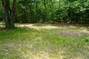
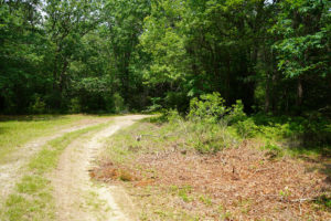
DEM says the development is only in the planning stages, but a platform with a permanent tent has already been erected. Campsites are being cleared, roads are being brush cut, small trees are already being turned into wood chips and no trespassing signs are up. This appears to have gone beyond the “planning” stage.
Wildlife Corridor
Charlestown’s Comprehensive Plan designates this area of Burlingame as Open Space/Conservation (OSC). The south side of Watchaug Pond and that part of Burlingame that includes the large camp ground and beach with picnic area and lifeguards is designated Open Space/Recreation (OSR). The OSC designation, which applies to North Camp, means the land is to be used for wildlife management and passive recreation such as hiking or snow shoeing. Camping with staff and facilities and especially any built environment is classified as active recreation. Back country camping is consistent with passive recreation.
DEM has partnered with Charlestown on many open space projects and the narratives of these grant applications or announcements are full of language describing the important wildlife corridor that extends from the Ninigret Wildlife Refuge at the coast, through Burlingame and the Carter Preserve and connects with the Carolina Wildlife Management Area in Richmond and then follows the western side of Rhode Island into Massachusetts. This wildlife corridor follows the same path as the North South Hiking Trail.
The Town of Charlestown, the Charlestown Land Trust, The Nature Conservancy, and many generous landowners have worked hard to protect land in this important corridor. Losing the conservation status of the North Camp area of this wildlife corridor to clearing, development and vehicle access seems unjustified when there are already 720 active camp sites in Burlingame on the south side of Watchaug.
Wetland Impacts
The concessionaire has already constructed a large platform right on the north shore of Watchaug. Even though this platform is constructed in the wetlands zone, no DEM wetlands permit is on record for this site. If the platform was constructed without oversight from the Wetlands Division of DEM, it doesn’t bode well for the concessionaire’s stewardship of Watchaug Pond.
Besides the direct wetland disturbance, camp sites can become eroded over time and result in storm water carrying sediment and nutrients into the pond.
Natural Heritage Area
The entire area of the old North Camp is in a state designated Natural Heritage Area. Natural Heritage Areas are areas of land that are known to have rare and endangered species. Much of Burlingame is in a Natural Heritage Area except for park land near the densely developed areas on the east side of the pond and where the active camp ground is on the south side of Watchaug. The undeveloped areas of Burlingame, including the now grown in North Camp, are still Natural Heritage Areas.
Public Access
The North South Trail Guide, a guide to Rhode Island’s premier hiking trail, includes an alternate route that passes through North Camp and visits the beach on the west side of Watchaug. The concessionaire has blocked the hiking trail access and other access to this part of Burlingame.
Traffic
Access to North Camp would be from Buckeye Brook Road, a winding and hilly rural road. Vehicles for 96 camp sites could have a significant impact on this road and the families that use this road to access their homes.
Police, Fire, and Other Emergency Support
Charlestown has added an average of fewer than 20 new dwelling units per year over the last 20 years. These new homes are a mix of seasonal and year round homes. Even though the camp ground will be seasonal, 96 camp sites represent the equivalent of more than four years of growth for the town. Like many households, the occupants of the 96 camp sites will have domestic disputes, medical emergencies, or accidents that will require support from our police department, ambulance, and other emergency services.
Lack Of Notice
All of these changes to land use and increased impact on neighbors, roads and public services should have been part of a conversation between the people of Charlestown and the RI Department of Environmental Management before the work began. It’s possible that the concessionaire who manages Burlingame for DEM began work without DEM’s knowledge, but even if work hadn’t begun, DEM still should have brought Charlestown into the planning for changes to North Camp.
What You Can Do
If you have concerns about the changes at Burlingame’s North Camp, you can express those concerns to DEM and your elected officials. When you email, consider adding all the addresses below to an email so all parties know what your concerns are.
You can write or call the Rhode Island State Parks Headquarters
Email: Thomas J. Rosa – dem.riparks@dem.ri.gov
Telephone: (401) 667.6200
You can write Janet Coit, the Director of DEM, or call the Director’s office
Email: Director Janet Coit – janet.coit@dem.ri.gov
Telephone: (401) 222-2771
Let your local elected officials know what you think
State Representative Blake Filippi – BlakeFilippi@blake36.com
State Senator Dennis Algiere – sen-algiere@rilegislature.gov
State Senator Elaine Morgan – sen-morgan@rilegislature.gov
Charlestown Town Council and Town Administrator – mstankiewicz@charlestownri.org
Or paste the following into the “To” field of your email
dem.riparks@dem.ri.gov, janet.coit@dem.ri.gov, BlakeFilippi@blake36.com, sen-algiere@rilegislature.gov, sen-morgan@rilegislature.gov, mstankiewicz@charlestownri.org
Click on any image below to open image gallery in lightbox.
June 28, 2019 @ 4:02 pm
“Like many households, the occupants of the 96 camp sites will have domestic disputes, medical emergencies, or accidents that will require support from our police department, ambulance, and other emergency services.”
Does DEM pay Charlestown taxes? on what? and how much?
If not then the costs for these items should be billed to DEM.
How are the costs for these items handled for the existing campsites?
June 28, 2019 @ 11:06 am
I think it important to hear what the concessionaire’s plans are, what DEM intends or has knowledge of and why these are all farmed out to private businesses that may not have conservation practices in mind or care about the impacts unless there is strong enforcement and regulations. DEM is not known for very strong enforcement of violations. There was also a primitive camp north of Buckeye Brook Rd on the river I think. (Pack in, pack out with not services) Will this be improved too? It is important that DEM enters into conversation with the town. It impacts our mapping and goals for the Town and should not be sprung on us.
I feel that there should be plenty of free public access to many bodies of water, the ocean, river, major ponds like Watchaug. Our state taxes fund these properties. They should be public with applicable conservation regulations. These DEM properties provide us with open space that protects our waters and wildlife habitat and do not require our management but they are still within our Town and we should be considered in their plans. Will these campers bring benefit to local businesses or bring in supplies. If not there is no benefit to Charlestown only expenses for services and more traffic and problems. An economic goal is to extend shoulder season tourism to benefit local business but will this achieve this without other negative impacts?
I don’t agree with closing established trails either.
June 28, 2019 @ 10:37 am
While I can not comment on this particular site, I will say that DEM has been responsible for recent land use changes in Exeter and these changes have also not been vetted by the Exeter’s Planning Commission. This includes not only the Browning Mill site which is currently being challenged, but also Beach Pond.
I am very sad to hear that the North Camp is undergoing this work, since it is a vital wildlife area. I have noticed many animal tracks on that beach when I have gone there over the past many years.
I wonder about what DEM Plans for human waste removal/processing since that area is so close to the wetlands and sits on the pond. It seems that they would have to clear a huge area for septic (96 sites which most likely hold at least two people at a time from April through September each year) and it would be a huge burden on taxpayers to place a public septic system in that area if it is even possible. For an idea of how large the area would need to be, see the septic leech field at the Fish Camp area in Burlingame and I suspect that is not actually up to code in terms of size and number of campers in that section of the campground. A last note about septic, will large RVs be allowed in the area? If not, then that will be more of a burden on the septic than Fish Camp because campers will be only using the restrooms and not their RVs. If RVs are allowed, they would need roads not only up to code, but possibly built extra wide to accomodate an emergency evacuation of RVs and an area for a waste/dump station for the RVs to empty their waste.
June 28, 2019 @ 10:15 am
Good article. Is it possible to obtain and publish the contract the DEM entered into and the names of the principals of the concession? In other words, who benefits?
My sense is this means 3 accesses the DEM controls to the Pond are now under lease to a private concession and either closed to public or a fee is required. North camp beach is the last place I know where the public could hike in and swim.
Steve