Scroll down to content
Charlestown Citizens Alliance
  • CCA on Twitter
  • CCA on Facebook
Menu
  • Home
  • Blog
  • Events
  • Open Space
  • Local Links
  • E-mail List
  • Election
  • Donate
Scroll down to content

Burlingame Park & Management Area

About
  • About
  • Location Map and Directions
  • Trail Map
Photo of deer in Charlestown, RI
Photo by Cliff Vanover

Burlingame State Park and Wildlife Management Area consists of over 3000 acres of land.

The State Park contains a campground and a smaller area for picnics, a boat launch, and beach for swimming.

The entrance to Burlingame State Park picnic area and the Kimball Wildlife Sanctuary is Prosser Trail, an exit off US Route 1. This state recreation area offers 50 fireplaces, toilets, drinking water, a swimming beach and a nearby DEM boat launch for boating and fishing.

The entrance to the park headquarters and camping area is off U.S. Route #1 in Charlestown.

More information is at the State Division of Parks  and Recreation website.

Burlingame Wildlife Management Area is bordered to the south by the Burlingame State Park. The land is managed for both wildlife protection and hunting. For hikers and mountain bikers there are many access points to the Management Area.

The Management Area is composed primarily of forest cover, with wetlands and some open fields. The Management Area surrounds most of Watchaug Pond and forms part of an 11-mile corridor of open space running from the Ninigret National Wildlife Refuge to the state’s Carolina Management Area. The North South Trail runs through Burlingame on its way to the Massachusetts border. The Management Area trails also connect to other parks such as School House Pond Preserve and Kimball Wildlife Refuge.

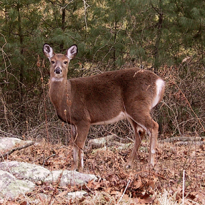
Species observed include rabbit, deer, fox, raccoon, muskrat, coyote, ruffed grouse, wild turkey, woodcock, waterfowl, songbirds, amphibians, reptiles, box turtles, and lots more.


Directions
There are multiple entrances to access the trails in Burlingame.

You can park at the picnic area. Turn north off Route 1 at Prosser Trail, turn left onto Sanctuary Road look for signs for the Park. Google Map at 41.380698, -71.675046

You can park at park headquarters entrance. Take Route 1 to Klondike Road, and then a right onto Burlingame State Park Road. Google Map at 41.360666, -71.702297

There is also access off of Buckeye Brook Road.

Comprehensive Trail Maps of all of Burlingame are available for sale at Great Swamp Press and Kettle Pond Visitors Center

Burlingame State Park Map shows the boat launch, swimming, fishing and swimming areas

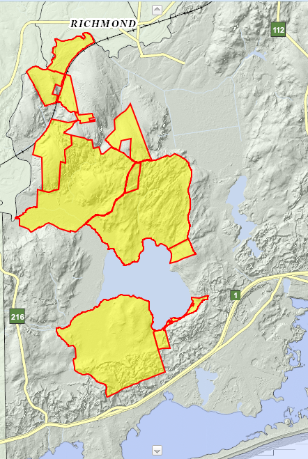
Public Recreation/Conservation Areas in Charlestown Rhode Island

Hikers on a Charlestown, Rhode Island trail

Table of Recreation Activities

Photo of the Pawcatuck River in the Sprague Preserve

Patricia Sprague Forest Preserve

Photo of Tucker's farm field with forest beyond

Tucker Woods Preserve

Photos of butterflies on goldenrod in the Carter Preserve

Francis C. Carter Memorial Preserve

Photo of frog swimming in the Great Swamp

Great Swamp Wildlife Management Area

Photo of a dragonfly

Pasquiset Pond Preserve

Photo of horses on a South Farm trail

South Farm Preserve

Photo of ferns

Richard Trails

Photo of a Yellow Warbler

Ninigret National Wildlife Refuge Lewis Trail

Photo of Mill Pond

Mill Pond Preserve

Photo of School House Pond

School House Pond Preserve

Photo of deer in Charlestown, RI

Burlingame Park & Management Area

Photo of Watchaug Pond

Kimball Wildlife Refuge

Photo of the Moraine Preserve

Charlestown Moraine Preserve

Photo of a frog

Ninigret National Wildlife Refuge Kettle Pond

Photo of Sandpipers

Ninigret National Wildlife Refuge Salt Pond

Photo of Mud Cove in winter

Pawaget Park

Photo of a Charlestown Milky Way

Ninigret Park (Town)

Photo of two women walking on East Beach

Ninigret Conservation Area

Photo of Charlestown Breachway

Charlestown Breachway

Photo of dunes at Charlestown Beach

Charlestown Beach

Photo of a Kayaker on Watchaug Pond

Local Boat Launches

Map of Charlestown ri open space access points

Location Map for Charlestown Open Space Parking and Access

Monarch Butterfly

Charlestown Open Space Galleries

Photo of people on Charlestown Beach

More Coming Soon!

« Kimball Wildlife Refuge» School House Pond Preserve

Donate Volunteer! Join Email List

Recent Blog Posts

  • An Atlantis Rising sand sculptureAtlantis Rising International Sand Sculpture Competition
    May 25, 2025
  • SoilTestCharlestown’s Earth Care Farm Featured in ecoRI Article
    May 25, 2025
  • Photo of Ninigret PondJoin CLT For An Early Morning Bird-Watching Paddle On Ninigret Pond
    May 25, 2025
  • Drawing of 158 houses on Ross Hill Road158 Dwelling Units Proposed In Ross Hill Road Development
    May 23, 2025
  • A picture of loose change (coins)Financial Town Referendum Monday, June 2
    May 23, 2025

Popular Pages

  • Recent Comments
  • Brief History Of Charlestown’s Elected Planning Commission
  • Community Survey Report
  • Charlestown Comprehensive Plan
  • Federal Railroad Administration Plan
  • Our Dark Sky
  • With 3 Billion Fewer Birds, What Should Charlestown’s Role Be?
  • Trash Talk – What Are The Causes And Solutions Of Litter In Charlestown
  • Extraction Industries In Charlestown
  • Wood-Pawcatuck Wild and Scenic Rivers
  • Great Flood of 2010
  • Sandy’s Impact
  • Invenergy’s Plan To Withdraw Water From Charlestown
  • Solarize Charlestown

CCA Mission

Identify and address significant public policy issues affecting the environment, economy, and future of Charlestown Rhode Island

  • About CCA
  • Contact CCA
  • Support CCA

CCA Issues

  • Good Government
  • Environment
  • Community
  • Taxes and Fiscal Responsibility
  • Responsible Development

Write To Us

Charlestown Citizens Alliance
Post Office Box 81
Charlestown, RI 02813
mail@CharlestownCitizens.org

  • CCA on Twitter
  • CCA on Facebook

↑

© Charlestown Citizens Alliance 2025