
Ruth Platner: Consider The Conservation Value of Burlingame North Camp
When hikers recently discovered a prototype wooden camping platform in Burlingame’s “North Camp”, Charlestown’s government and citizens learned only by accident that there was a plan to revive camping on the north side of Watchaug Pond. In response to queries, the State Parks Division of Rhode Island’s Department of Environmental Management (DEM) spoke of development of 96 campsites in North Camp. Some would be permanent tents on wooden platforms – others would be cleared areas where campers would park and pitch their own tents. In the days that followed the initial discovery, the DEM timeline for development moved from “probably next year” to “there isn’t a decision yet“. Whatever the timeline, it appears to still be in the early planning stage when the town and its citizens may be able to impact the final decision.
Charlestown’s Comprehensive Plan designates this area of Burlingame as Open Space/Conservation. The camp hasn’t been used in over 20 years and campsites have overgrown, trails have narrowed, and the forest and its wildlife have returned. The old camp sits on the edge of Watchaug Pond in the center of a 1000 acre parcel of unfragmented forest between Kings Factory Road and Buckeye Brook Road. Beyond those roads, the camp is part of about 6000 acres of protected open space. But the roads fragment the forest and the camp will too.
Unfragmented forest of over 500 acres is increasingly rare in Rhode Island and this area on Watchaug should be protected for conservation and passive recreation. The camp is at the center of a State designated Natural Heritage Area. Within the vicinity of the camp are six species of State Concern, one State Threatened species, and two State Endangered species.
When the camp was created, Charlestown had a small population and Charlestown like much of South County was mostly undeveloped. But land use has changed dramatically over the decades and the importance of the remaining large unfragmented forest parcels has greatly increased for species that depend on these large parcels.
Because of the Natural Heritage designation, a new camp at this location would probably not be proposed today. Before reviving the old camp, the location inside the Natural Heritage Area and the wildlife impacts of forest fragmentation should be carefully considered.
Charlestown already provides 78% of the State camping sites. The State operates five campgrounds and three are in Charlestown. Charlestown hosts 815 of the 1042 State campsites. There are 720 sites in Burlingame, 75 at the Charlestown Breachway, and 20 sites at East Beach. In comparison, Narragansett has 182 sites at Fishermen’s Memorial Campground, Glocester has 45 sites at the George Washington State Campground, and no other town hosts any State campgrounds.
I hope that before siting a campground in a Natural Heritage Area inside a large unfragmented forest that DEM will fully explore other options.
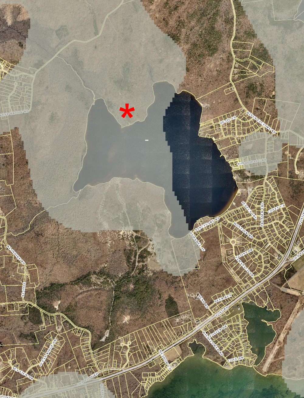
The red star in the image above shows the location of part of North Camp. The full area of the camp is larger than the star. The grey overlay shows the Natural Heritage Area. Kings Factory Road is on the east (right side of map), and Buckeye Brook Road is on the north (top of map), inside the Natural Heritage Area.

You can learn more about the author, Ruth Platner, at her profile page.
The banner image for this post is a photo of Watchaug Pond by Cliff Vanover.
July 22, 2019 @ 9:21 am
I have hiked this area for over 19 years. A lovely place to enjoy nature. First thing I observed was in the clearing of the access path both Princess Pine and Lady Slipper Orchids (only orchids found above Mason Dixon line) were destroyed.
We moved to Charlestown 19 years ago drawn to its quiet rural environment. Please continue to protect this gem.
July 9, 2019 @ 7:48 pm
It would be fantastic if they would re open north camp. I remember camping there as a kid.
July 9, 2019 @ 9:26 am
I am totally against it. We do not need the pollution it will create and the increase of cars in the area.