Railroad Impacts from Shannock Road to the Carter Preserve
Maps and descriptive text by Cliff Vanover.
In this post we’ll look at the proposed bypass and see how it would impact Charlestown, highlighting potential changes to buildings, roads and the landscape. This analysis, part informed speculation, is based on information derived from the EIS, including the macro scaled maps in the Appendix, as well as on basic earth engineering principles, and on my familiarity with the countryside in this part of town.
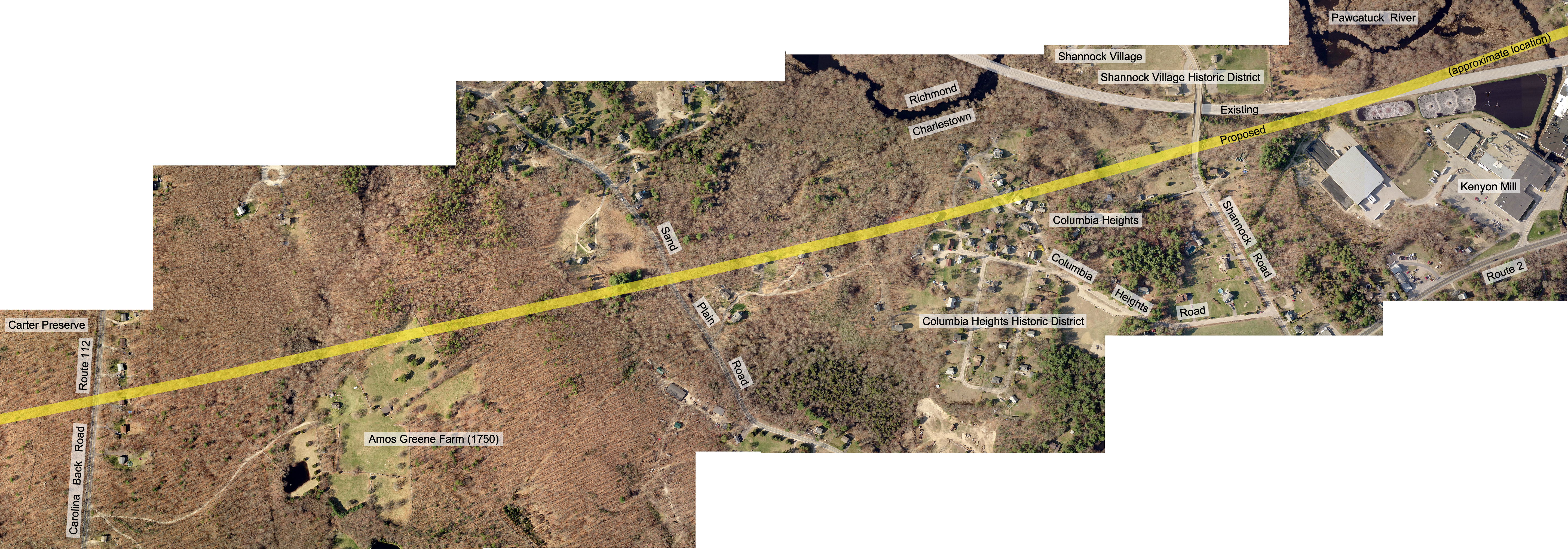
We begin at the border of Richmond, heading west southwest towards NYC on the proposed bypass route. As noted in the recent post about the impact of the bypass on the village of Kenyon, at the border of Charlestown and Richmond the tracks would be carried aloft on a nearly 1/2 mile bridge roughly 25 or 30 vertical feet above the Pawcatuck River, wetlands and floodplain, and more importantly, high enough above the existing tracks to allow trains below to pass, since the existing tracks would still be used were the bypass built. On the west the bridge would terminate about 400′ short of Shannock Road. The tracks would then cross Shannock Road roughly 150′ south of the Shannock Road Bridge (also the border of the Shannock Village Historic District) that now carry traffic over the existing tracks. If the bypass were built, Shannock Road would probably become a dead end. About 700′ past Shannock Road the bypass would enter the historic Columbia Heights neighborhood and the Columbia Heights Historic District. A low to moderate income community, Columbia Heights has benefited from federal funding over the years. And as a low/mod income community, there are issues of Environmental Justice not addressed in the FEIS.
About 1500′ beyond the western edge of Columbia Heights the tracks would arrive at the bottom of a hill by Sand Plain Road. From the road to the top of the hill, the bypass would gain about 100 feet of vertical elevation over a distance of 3100 horizontal feet. This would result in a grade of more than 3%, which is steep for trains. The FRA would probably require a more gentile grade. An incline with a grade of not more than 2% would need a ramp about 4000′ in length. A ramp this long would probably begin in Columbia Heights. This would be a large structure, composed of rock, sand, gravel, soil and concrete. At Sand Plain Road, the tracks would be about 30′ above the surface of the road. Cars and trucks would pass through a tunnel at the bottom of the embankment. Leaving Sand Plain Road, the bypass enters and crosses historic Amos Greene Farm. Further up the hill the tracks would pass close to the farm’s historic 1750 farmhouse. Here, the inclined embankment would end and a “trench” would begin. This would deepen as the bypass continued uphill towards the peak of the hill on Carolina Back Road. A number of houses along the road here would have to be demolished to make room for the trench. Trenching involves scraping off the overlying soil, then blasting the underlying bedrock. The trench would be deepest at Carolina Back Road, allowing trains to pass under the road. On the other side of the road the bypass would enter the Francis Carter Preserve, one of The Nature Conservancy’s premiere natural areas and one of the largest open spaces in southern Rhode Island. Blasting bedrock and trenching would probably occur here too, possibly on a greater scale than on the other side of the road since the bypass would pass through an extensive area of bedrock before reaching the large field at the base of the hill.
The above description does not include all the other land the Federal Railroad Administration would condemn in Charlestown. which they would need for equipment and material used in constructing the bypass. How many acres of land they would need and where would those parcels be located they don’t say, but we should assume it could be a significant amount of land.
Visit Our Railroad Page For More On This Issue
January 12, 2017 @ 11:27 am
Excellent research and work performed by Cliff Vanover here. Boy – who ever could have imagined that all his great work on regional nature trail maps would ever result in his ability to provide this very detailed synopsis of all the disruption and destruction a new train bridge, and new train tunnel – not to mention a 220 mph bullet train – would have on neighborhoods, homes, property values, farms, blasting bedrock in the Carter Preserve, not to mention the intrusion into Tribal Lands and it’s impact on the lives of those who will be displaced from or disrupted in their homes.
One really does need to walk the trail (as Cliff more or less has) to get a full appreciation of the extent of the impact and destruction in this proposal. If this remains the plan, even if it’s not funded for decades, the looming destruction has it’s impact on the town immediately, preventing homeowners from being able to sell their homes, reducing equity and home/farm value for needed repairs and other impacts, and really handcuffing the town and residents in general.
That’s a lot to ask Charlestown residents (and anyone who values natural conservation) to sacrifice for a train that won’t even stop in Kingston or Westerly – and a dubious cost-benefit analysis for any taxpayer to spend $132 billion to save a small handful of people a few minutes of travel time.
Thank you to all on the Town Council, Town workers, Planning Commission members and CCA members and supporters for staying on top of this and helping to rally and organize the opposition.
Seems like the federal government is going out of it’s way to keep everyone in the dark (when they have the ability and the what should be an obligation to directly inform impacted parties and citizens) but this overview of the route and impact sheds a lot of helpful light. The time to fight back is now – if this makes it into Tier II it’s likely to remain there no matter how much false assurances anyone gives that “there will be time to change it later” and the damage will be done no matter if or when the actual demolition of these neighborhoods takes place.
January 10, 2017 @ 8:46 pm
my home, at 265 Carolina Backroad, would be taken for this bypass to occur. As stated at town meeting this evening, it would not happen for many years ,but, … if this bypass route is chosen, I have no resale value left and cannot see any sale of it, knowing what MAY happen in years to come., never mind the environmental impact, the historical impact, the farming impact… I am 100% opposed to this proposal.